The Gorge of Eternal Peril
 It's rare for any speaker to draw a standing ovation from the OSCON audience, but that's what David Rumsey did last week. And Rumsey isn't one of the heroes of open source software. He's a philanthropist who collects historical maps, scans them at high resolution, and publishes them on the Internet
 as open content that anyone can access and repurpose 2. His motive is partly to connect many people to content that few would be able to view in a museum:
I thought about donating it to a university, but their libraries focus on preservation, they'd have put my collection in a vault and there would have been no access. Along comes the Internet, and I found we could do even more with the digital content than with the originals. We serve over 7000 visitors a day. A typical map library will serve 200 visitors a year.
But expanding access, while lovingly preserving the feel of the artifacts he has collected, is only the tip of the iceberg. Although you can view these images in the expected ways -- zooming in and out, panning around -- Rumsey wants us to do more. He hopes we'll use the online maps to tell one another stories about history, geography, culture, and the environment. To that end, he's commissioned the development of a family of clients. For starters, there's a browser-based interface that you can use to view, pan, and read about the maps. Then, using an installable Java client, you can add annotations to the maps, crosslink points on different maps, and link from points on maps out to the web.
For example, after OSCON I spent the weekend in Vancouver, British Columbia, for the Vancouver Python Workshop where, on Saturday evening, I gave one of the keynote talks. (Thanks to Paul Prescod for the invitation to visit beautiful Vancouver for the first time, and to everyone else I met and enjoyed meals and drinks and conversation with.) On Sunday, I skipped out of the conference for a few hours with Stewart Butterfield and his wife Caterina Fake, for a visit to Lynn Canyon Park which is here.
Stewart and Caterina took some pictures of our visit to Lynn Canyon, including this one of me crossing The Gorge of Eternal Peril -- highly appropriate in light of the Python theme of the weekend.
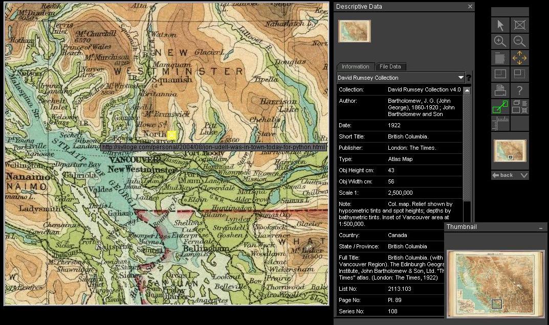
If you use David Rumsey's Java client to visit the 1922 J.G. Bartholomew map of British Columbia, you'll find a marker I've left there. Or, just enlarge the screenshot and take a look. The yellow splotch is an anchor. It points to Stewart's page, which displays images of our excursion sourced from Flickr, the photo-sharing site that their company, Ludicorp, is building.
David Rumsey's vision is very much about this way of weaving together contemporary and historical images and text. He said:
We're revealing the source code of cultural systems. And we'll be able to build new interpetations on top of that content. The growth of online library content will be accelerated by enabling people to build collections of images and text, collaboratively.
You can read more about his presentation here and elsewhere. Like everyone else, I was blown away by the GIS viewer, which -- for those of the maps that have been geocoded and "georectified" 1 -- enables you to load up (for example) a historical map of a San Francisco neighborhood, a modern street map, and a satellite image, and then do amazing things: blend from one to another, zoom all of them in lockstep synchronization.
Noticing that buildings now stand on what was once a marsh is one example of the insight you can gain from this technology. While flying home, a grander vision occurred to me. In the airport, I picked up a copy of (Vancouver native) David Suzuki's environmental polemic, From Naked Ape to Super Species. In it, he quotes from Alan Durning's How Much Is Enough?
Play back the last 10,000 years sped up, so that a millenium passes by every minute. For more than seven minutes, the screen displays what looks like a still photograph -- the blue planet Earth, its lands swathed in a mantle of trees. After seven and a half minutes, there's a tiny clearing of forest around Athens. This is the flowering of classical Greece. Little else changes. At nine minutes -- 1,000 years ago -- the forest gets thinner in parts of Europe, Central America, China and India. Twelve seconds from the end, two centuries ago, the thinning spreads a little farther in Europe and China. Six seconds from the end, eastern North America is deforested. This is the Industrial Revolution.
What happens in the final three seconds is, as you can imagine, quite alarming. But words, no matter how carefully crafted, can't really paint the picture. The maps of the Rumsey Collection, with all of their meticulous detail and surpassing beauty, evoke a powerful emotional response. Woven together with contemporary maps and data, along with links, images, and texts that document our own experience of the landscape, they could help make the abstract processes of environmental change seem real and personal.
1 For example: Lewis and Clark had a problem keeping their clocks wound, so their longitudes had to be corrected.
2 It's been pointed out to me that 'open content' was the wrong way to describe the collection. The images are in fact copyrighted, and reproductions are for sale. A better way to describe the collection might be as an 'open service' -- one that defines a canonical namespace for a set of images and encourages you to link to them.
Former URL: http://weblog.infoworld.com/udell/2004/08/03.html#a1052
 It's rare for any speaker to draw a standing ovation from the OSCON audience, but that's what David Rumsey did last week. And Rumsey isn't one of the heroes of open source software. He's a philanthropist who collects historical maps, scans them at high resolution, and publishes them on the Internet