It's been just over a year since I made a screencast showing how online mapping services can be used to annotate maps with text, photos, or even movie clips. In 2005, you had to be a rocket scientist to do this kind of thing. In 2006, online mapping has become much more accessible, and it's opening up interesting opportunities for nearly everyone.
Here's an example. One of my favorite local hikes begins at Roxbury and Lincoln, climbs past Robin Hood Park, winds up and then down Chapman Road, and finishes along Eastern and finally Lincoln. There are gorgeous views along much of this route. But it's been hard to enjoy those views lately. Now that the snow has disappeared, you can't help noticing that the whole route is strewn with litter.
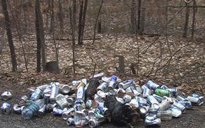 Yesterday at one of the worst spots, just downhill from 333 Chapman, I bagged up a pile of bottles and cans. Then, using a site called Wayfaring, I created a map that traces my route, pinpoints the place I cleaned up, and displays a photograph of what I found there.
I'll take another empty bag with me next time I go. If you're headed up that way you might want to do the same. There's a scattering of litter along the whole route, but the stretch between waypoints 1 and 2 on the map I made is most in need of attention. If you do pitch in, you might also want to update the map with locations, comments, or photos.
Coordinating the cleanup of litter dumped by thoughtless jerks is, of course, only one possible use for this important emerging technology. As online maps become easy for anyone to create and share, they'll enrich and empower communities in all sorts of ways.